 |
Dutch Nautical Chart, ca. 1687.
catalog
record
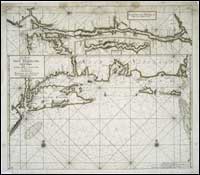
This Dutch nautical chart by Johannis
Van Keulen contains the earliest detail extant of the Hudson
River. It is oriented east-west at the top of the chart, above
a chart of the coast from New Jersey to what may be Cape Cod.
Henry Hudson, English explorer, sailed up the river that bears
his name in 1609, but no charts were produced as a result
of his journey. Because he was sailing for the Dutch East
India Company, seeking a northwest passage across North America,
his ascent up the River to Albany provided the Dutch with
their claim to the New York region, or "Novi Belgii." |
The Hudson River was named by the Dutch the North
River, which is still an alternate name for the river, often seen
on nautical charts today. The East River and the South River, or
Delaware River today, were two other notable water routes on early
Dutch charts.
The Hudson River provided valuable access to the
interior of the continent and to the fur trade. Early patroonships,
or large rural estates, were established by the Dutch along the
shores of the Hudson, and many Dutch names remain on the landscape
today as a result.
To read more about the Hudson River and its history
see:
The Hudson, by Carl Carmer, 1968. catalog
record
The Hudson through the years, by Arthur G. Adams, 1996.
catalog
record
Juet's Journal, the voyage of the Half Moon from 4 April to
7, November 1609. catalog
record
|


