|
The Atlantic Ocean was a bridge, not a barrier,
connecting America to the West Indies and European trading partners.
Regular crossings were established by the Spanish soon after Columbus's
voyages, linked to the trade winds that facilitated sailing over
the expanse of water.
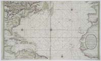 |
Dutch Oceanic
Chart
catalog
record
On this beautiful Dutch chart of the
"Spannish Zee betwixt t' chanell and the I. Cuba,"
the east and western shores of the Atlantic are hand-colored
in beautiful hues of yellow, pink, and green. |
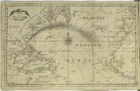 |
Chart of
the Atlantic Ocean
catalog
record
In the 18th century, Benjamin
Franklin described and mapped the Gulf Stream, which sailors
had long known made for faster sailing toward England than
the reverse journey.
|
|


