|
Section I Selections from the C.W. McAlpin Collection
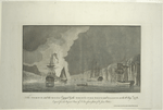
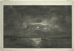
Section I Dawn of the American Revolution, 1768-1776Section IIIPerspective Views Perspective views (or vues d’optique) are prints designed to be viewed through an apparatus consisting of a mirror and a convex lens. They typically have strong diagonal compositions and bright hand-coloring, which enhance the sense of depth when viewed through the device. Thousands of these views were published in Europe during the 18th century, with cityscapes and local landmarks being the most popular subjects. While these four views of events in Revolutionary New York appealed to a foreign audience’s curiosity about the war abroad, they are not architecturally accurate. The engraver, Franz Xaver Habermann, had never visited New York, so he adopted typical European streetscapes as backgrounds.
Die Anländung der Englischen Trouppen zu Neu Yorck / Debarquement des troupes engloises a Nouvelle Yorck [The Landing of British Troops in New York] After the British evacuated Boston, they withdrew to Halifax. General George Washington anticipated that their next move would be to seize New York and rushed to set up his troops in the city. Washington’s prediction came true, and in the summer of 1776 an awe-inspiring British fleet carrying over 30,000 troops sailed into New York.
Die Zerstörung der königlichen Bild Säule zu New Yorck / La destruction de la statue royale a Nouvelle Yorck [The Destruction of the Royal Statue in New York] The Declaration of Independence was read aloud to General George Washington’s troops in New York on July 9. The stirring words incited a crowd to storm down Broadway and topple the statue of George III that stood on Bowling Green. The body of the statue was melted down to make ammunition for the Continental Army.
Der Einzug der königlichen Völcker in Neu Yorck / L’entré triumphale de troupes royales a Nouvelle Yorck [The Triumphant Entry of Royal Troops in New York] Although Washington’s troops successfully retreated to Manhattan after their defeat at the Battle of Long Island, their position was tenuous. Their location at the southern tip of the island was vulnerable to attack, and thousands of militiamen were decamping from the Continental Army. At the urging of his officers, Washington ordered his troops to abandon the city and head north toward Fort Washington. The British marched into New York and occupied the city until the end of the war, in 1783. Although it was already home to a sizeable Loyalist population, the city soon became a refuge for British sympathizers.
Schröckenvolle Feuersbrunst welche zu Neu Yorck … / Representation de feu terrible a Nouvelle Yorck … [The Great Fire in New York] Pursued by the British, Washington and his men retreated to northern Manhattan on September 15, 1776. General Nathanael Greene advised that they burn New York before leaving, but the Continental Congress advised Washington to leave the city intact. Six days later, a fire broke out in lower Manhattan and destroyed almost a third of the city. The British claimed that numerous fires had sprung up simultaneously and immediately accused the Americans of sending spies to commit arson. Washington himself pondered whether a “misguided patriot” was responsible. The source of the fire continues to be debated by historians.
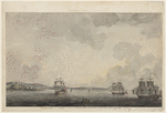
In the summer of 1776, a colossal British fleet, the largest naval expedition ever launched by Great Britain, assembled in New York. While the Howe brothers were preparing their plan of attack, two warships, the Phoenix and the Rose, sailed up the Hudson River to disrupt Continental communications with New Jersey. They reached almost as far north as Tappan Zee before attacks by patriot fire ships convinced them to rejoin their fleet. Sir James Wallace, a captain in the British navy, sketched this scene. His sketch served as the basis for an oil painting by Dominic Serres, the marine painter to George III, as well as a model for this hand-colored aquatint by an anonymous printmaker. It was published by Joseph F. W. Des Barres, a prominent British map publisher who issued a series of North American charts and coastal views known as The Atlantic Neptune.
The British armada anchored off Staten Island to await the launch of the New York campaign. Although leaders from both sides met to discuss a peace offer from Britain, the meetings came to naught and the patriots prepared for the inevitable offensive attack on Brooklyn. During this waiting period, a British naval officer aboard one of Howe’s ships, possibly Thomas Davies, painted this watercolor. The Royal Naval College at Portsmouth and the Royal Military Academy at Woolwich included instruction in draughtsmanship to prepare officers for making surveys and maps.
The Battle of Long Island (originally called the Battle of Brooklyn), the first large-scale battle of the American Revolution, was a resounding defeat for the Americans. They were outmaneuvered by the British, who came ashore at Gravesend in southern Brooklyn and moved north along poorly protected routes toward the Continental Army’s fortifications in Brooklyn Heights. Although the Americans were besieged, Howe decided not to pursue them any further, and Washington’s troops were able to retreat to Manhattan. Thomas Davies, a British naval officer, possibly sketched this scene of several ships that participated in the battle, with Governors Island in the distance.
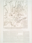
This map traces the British maneuvers in New York during August to October 1776, from the Battle of Long Island to the American evacuation of Manhattan. After they forced the American troops from Brooklyn, the British attacked at Kips Bay and then pursued the Continentals northward before finally capturing Fort Washington. The map was engraved in London by William Faden, the geographer to the king, after a survey by an unknown British officer. It is the fifth and final issue of the “Howe War Plan,” which was continually updated to reflect additions or corrections.
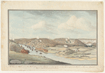
Washington’s men were on the move after retreating from New York City. They headed north and fought the Battle of Harlem Heights (September 16) and the Battle of White Plains (October 28). Fort Washington, a five-bastion fort atop Manhattan’s highest point (present-day Fort Washington Avenue and 183rd Street), was the Continental Army’s final stronghold in New York. The attack on Fort Washington was a resounding defeat for the Americans. The British captured the fort and its plentiful supplies, and took almost 3,000 men prisoner. Thomas Davies depicts the British soldiers crossing the Harlem River toward Fort Washington (in the center). At the far left is the house of Roger Morris (the present-day Morris-Jumel mansion), which Washington briefly used as his headquarters and which was afterward occupied by British and Hessian officers.
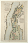
Fort Washington, located in present-day Washington Heights, was the site of George Washington’s most serious defeat: the British not only captured the fort and its large cache of weaponry and supplies, but also took close to 3,000 prisoners-of-war. The Right Honorable Lord Percy participated in this attack and the following day commissioned Claude Joseph Sauthier to draw a survey of the area. The prolific London map publisher William Faden issued this engraved version of the survey. Faden also published another map in this exhibition, the “Howe War Plan.”
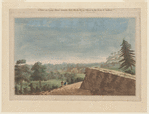
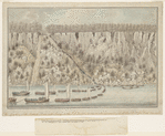
Several days after capturing Fort Washington, General William Howe ordered his troops to take possession of Fort Lee, located across the Hudson in New Jersey. Led by General Cornwallis, the troops rowed across the river and scaled the Palisades. When they arrived at their destination, the British found Fort Lee abandoned. The Continental Army had been warned about the attack and fled toward Philadelphia. |