|
|
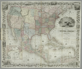
The Colton firm reissued their standard United States map in 1849
and highlighted the gold region in California by adding regional
labels only. Lettering for "United States" still floats
diagonally across the map, avoiding the old Mexican turf. The old
boundary lines are documented with notes about the treaties
defining them from 1819 and 1828.
The eagle cartouche is surrounded by emblems of American power and
trade. Progress is shown in the various steamboats and trains.
Produce and trade goods decorate this image of a Western port
scene. The heavily decorative border includes several Western
scenes, Mexican cowboys rounding up wild cattle, the Cathedral in
Mexico City, Willamette Falls, Oregon, and Astoria, Oregon.
The newly won territory of "Upper or New California" is
named, with the pre-Gadsden Purchase border clearly shown, along
the Gila River. The Gadsden Purchase of 1854, of 30,000 square
miles of northern Mexican territory (now southern Arizona and
southern New Mexico), was the last major border change of the
Mexican Republic. "New Mexico" appears as a narrow
vertical strip covering the Santa Fe Valley.
Reproductions and Permissions
|
|