|
Humanities and Social Sciences Library > Collections & Reading Rooms > Print Collection > MOVING UPTOWN Section X (Including panoramas, houses, Brooklyn Bridge)Panorama of New York and Vicinity. 1866 Julius Bien (American, b. Germany, 1826–1909)
By 1864, half the city's population lived north of 14th Street. By 1867, the edge of the city had pushed as far north as 59th Street, with brick row houses on the crosstown streets from Third Avenue to the East River, and four- and five-story tenements lining First, Second, and Third avenues. Developers were building rows of brownstones and frame houses along the side streets in the West 40s and into the West 50s. Fifth Avenue was the best-known address in the country, though many of the "old guard" took a dim view of the opulent, but not always tasteful, mansions of the nouveau riche, who were sometimes referred to as "the Avenoodles" and "the Shoddy Aristocracy." After the Civil War, the earlier hesitation about the future of Fifth Avenue vanished, and speculators and the great families purchased land well ahead of the city's edge. Though prices were high, homes were in such demand that construction along Fifth Avenue was filling up five, sometimes even ten blocks ahead of the rest of the city. Like Broadway earlier in the century, Fifth Avenue now led the urban procession up Manhattan. The economy was flourishing. One-third of the nation's exports and more
than two-thirds of the imports passed through the city. The city was the
financial center of the nation, and the main offices of most of the fast-growing
corporations were situated in New York. With vast reserves of cheap labor,
provided by the ever-growing immigrant population, the city was an important
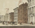
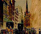
manufacturing center as well. Endicott and Company (American lithographic firm, 1852–86) In the 1850s, New York was already the printing center of the United
States, and by the next decade the city had 51 newspaper offices, 17 book
publishers, and 81 job offices. The intersection of Park Row (on the right)
and Nassau Street around 1860 earned the name "Printing-House Square," since
many of the newspaper and publishing offices had congregated in that neighborhood.
Among them were the Times (on the site of the Brick Presbyterian
Church, which sold for $270,000 and then was demolished), the New York Tribune (the
publishers of this print, Baker & Godwin, had offices in the Tribune building),
the Globe and Commercial Advertiser, and the Recorder.
South of the Times building were the offices of the World and
the Scientific American. The area also was occupied by paper manufacturers,
advertising agencies, photographers, printers, and printmakers, including
Currier and Ives at 152 Nassau Street. Ferdinand Mayer and Sons (American lithographic company, 1854–about
1877)
There were also proposals to cope with street traffic by going underground,
including this unrealized project for an Arcade Railway, which was authorized
four times by the New York State Legislature, but vetoed each time by the
governor. The project had another opponent as well: Boss Tweed, who was
concerned this plan would end the kickbacks he received from the surface
transportation companies. The first subway construction was undertaken
only after the turn of the century. Anonymous The Bowery, extending from Chatham Square to Cooper Square, had been
on the edge of the city around 1800, but as the population moved north,
the Bowery was for a time home to the middle class and the well-to-do,
and the street, with its taverns, oyster bars, and minstrel theatres, rivaled
Broadway as a place to go for entertainment. The Bowery Theater, which
opened in 1826, was the largest auditorium in the country. As the neighborhood
declined in the 1840s, the Bowery became the shopping and entertainment
street for the nearby boardinghouse and tenement district, home to growing
numbers of immigrants, and after the Civil War it was a place to go for
cheap entertainment and nickel museums. The elevated line built over it
in 1878 sealed the area's fate, and the Bowery became synonymous with the
drunks and derelicts that frequented the neighborhood's cheap lodging houses
and missions. Between 1842 and 1866, D. T. Valentine's Manuals of the Corporation
of the City of New York commissioned artists to depict historical and
contemporary New York. Although some of the reconstructions of 17th- and
18th-century Manhattan are reasonably faithful copies of earlier prints and
drawings, others are pure fabrications. The most interesting prints are contemporary
records of the 19th-century city. Many of these views show wonderful mixtures
of old and new architecture, typical of the fast-growing city as it engulfed
older farms, country residences, and taverns. Among them are several lithographs
of the Murray Hill district, near the present site of The New York Public
Library. Major & Knapp (American lithographic firm, 1864–1870s) Murray Hill became the fashionable place to live in the 1850s. Not only
was the land elevated, with abundant sunlight and good drainage, but there
were very few extant taverns and old houses, like the Caster Estate, to
impede growth. By the end of the century, many prominent families, including
the Belmonts, the Rhinelanders, the Tiffanys, the Havemeyers, the Phelpses,
the Delanos, and the Morgans had mansions in Murray Hill. Major & Knapp (American lithographic firm, 1864–1870s) Though the Murray Hill neighborhood had changed dramatically around
it, this country inn survived into the 1860s on the site of what is now
the Mid-Manhattan Library. Major & Knapp (American lithographic firm, 1864–1870s) Park Avenue was not always a fashionable street. The New York & Harlem
Railroad hauled trains along Park to the Centre Street terminal, but by
the early 1850s, the tracks were sunken below street level, and between
34th and 38th streets, a 40-foot-wide landscaped mall covered the center
of the street. The Herald wrote, "when the plots thus enclosed
are enhanced with shrubs and flowers . . . they cannot fail to vastly enhance
the general appearance of the locality." Sarony, Major & Knapp (American lithographic firm, 1857–67) Hills and rocky outcroppings had to be cleared and leveled as the city
moved uptown, a formidable task as this view of 42nd Street looking north
suggests. At this date, occasional frame houses and groups of row houses
dotted the landscape, but within a few years, after the Civil War, the
East Side east of Madison Avenue would develop into a working-class and
middle-class neighborhood. Tenements lining First, Second, and Third avenues
pushed northward beyond 42nd Street into the Upper East Side and eventually
to Harlem. Red brick and brownstone row houses for middle-class families
gradually filled the side streets from the 60s to the 80s. Already by 1858
a horse-drawn trolley was traveling up Second Avenue to 122nd Street, permitting
residents to enjoy suburban living and lower housing costs, and to commute
to work downtown. Major & Knapp (American lithographic firm, 1864–1870s) The Upper East Side was rapidly losing the landmarks of its rural past
as small estates along the East River were sold off, and country houses
were torn down or converted into taverns or boardinghouses, before ultimately
being replaced by row houses or tenements. The Brevoort Estate shared this
fate. By 1805 it had become "Cato's" (Cato Alexander's Tavern), and eventually
was demolished around 1853. By 1861, a writer for Harper's Monthly surveying
57th Street from a boat in the East River commented that the "streets are
fast finding their inexorable way . . . to the river in this neighborhood,
as they had done below." The shot tower in the left background, seen in
Fay's Views in New-York and Its Environs, survived into the 20th
century. Augustus Fay (American, b. about 1824, active 1848–1870s) In 1869, Cornelius Vanderbilt consolidated the New York & Harlem
Railroad with the New York & Hudson River Railroad, and at 42nd Street
between Lexington and Madison avenues constructed Grand Central Terminal,
which was completed in 1871. Never successful, this building was constantly
being rearranged and enlarged. Soon after the depot was built, Vanderbilt
began to lower the tracks in a deep cut, which was roofed over, and later
enclosed in a tunnel that began at 96th Street. The 1871 terminal was demolished
in 1910, replaced in 1913 by the present Grand Central Station. Charles Magnus (American lithographic firm, 1854–77) This view of Broadway at 42nd Street around 1899 was published by Charles Magnus, who produced urban views of cities across the United States as letterheads on notepaper. By the turn of the century, New York's theatre and entertainment district had moved north past Madison Square, up Sixth Avenue to Herald Square, and on into the 40s; many of the newspapers were soon to leave Printing-House Square and follow suit. Delmonico's Restaurant offers an interesting indicator of changing fashion
in neighborhoods. Founded in 1827 at the corner of South William and Beaver
streets, the restaurant, after the fire of 1845, opened a new restaurant,
now with a hotel at 25 Broadway. By 1862, Delmonico's had moved uptown
to Fifth Avenue and 14th Street, and by 1867 had moved again, to West 26th
Street between Fifth Avenue and Broadway. In 1898, Delmonico's relocated
once again, now to 44th Street. Charles Magnus (American lithographic firm, about 1854–1880s) The old Plaza Hotel, on the site of the present structure (built in
1907), offered spectacular views of Central Park. Across the street on
the northeast corner of 57th Street was the Mary Mason Jones mansion. Tbe
model for Mrs. Manson Mingott in The House of Mirth, written by
her niece, Edith Wharton, Mrs. Jones had built her home on 57th and Fifth
Avenue in 1869 when this was north of the city's fashionable limits. As
Mrs. Mingott, she was portrayed by Wharton, "sure that presently the hoardings,
the quarries, the one-time saloons, the wooden greenhouses in ragged gardens,
and the rocks from which goats surveyed the scene, would vanish before
the advance of residences as stately as her own. . . ." By the 1880s, Fifth
Avenue had been invaded by fancy shops, jewelry stores, hotels, and boardinghouses
almost up to Central Park. The only truly residential portion of Fifth
Avenue began at about 50th Street with a parade of Vanderbilt family mansions
stretching from 51st to 58th streets. Major & Knapp (American lithographic firm, 1864–1870s) The West Side rapidly filled up into the West 50s during the 1840s and
1850s; even Tenth and Eleventh avenues past 42nd Street were respectable
addresses. For a time, excitement over Central Park encouraged some New
Yorkers to believe that the West 50s around Seventh and Eighth avenues
might replace Fifth Avenue as the fashionable address. By the 1860s, Seventh
Avenue was "very wide and well paved" and the site of "a number of fine
edifices . . . in course of erection, under the pressure of Central Park
excitement." The Herald also observed that the West Side had "a
superior class of residents than those on the East Side of town," the not-so-hidden
implication being that more foreigners lived on the East Side, while West
Side residents were more apt to be native-born. Anonymous Poor public transportation hampered the growth of the Upper West Side. A single car traveled back and forth between 59th and 84th streets along Eighth Avenue, and a stage rolled down Bloomingdale Road only once every hour. Summer estates, like Fernando Wood's, would not be threatened by the city's growth for almost another 30 years, not until after the opening of Riverside Drive and the Ninth Avenue El. Fernando Wood, Mayor of New York in 1855–57 and again in 1859–61,
had a checkered reputation. Convicted of defrauding investors during the
Gold Rush, as mayor he nevertheless proposed innovative city programs,
though few of these were realized. A role model for "Boss" Tweed, he defended
slavery in the South for economic and racist reasons, and had proposed
New York become a "free city" in 1861. Popular opinion quickly turned against
him after the attack on Fort Sumter, and the pro-Southern Wood was defeated
in the mayoral election of December 1861. Sarony, Major & Knapp (American lithographic firm, 1857–67) Until the mid-1880s there was still considerable open land on the Upper West Side, which was dotted with shantytowns, old country homes, farms, and taverns. When an opulent apartment building was built on Eighth Avenue (now Central Park West) between 72nd and 73rd streets in 1881, wags commenting on its remoteness said it might as well have been in the Dakotas –and the name "Dakota" stuck! Even the opening of Riverside Drive and the Ninth Avenue El in 1880 did not immediately fulfill the promise of the glorious future that many had predicted for the Upper West Side. Only in the mid-1880s did the building boom begin in earnest. Bloomingdale Road was renamed the Boulevard in 1868, and only in 1899
was the street officially named Broadway. Anonymous Even though Harlem was about three miles above the northern edge of
the city proper, public transportation (the New York & Harlem Railroad)
connected Harlem to downtown in 1837, and by the late 1850s horse-drawn
trolleys reached Harlem via both Second and Third avenues. The Evening
Post (1852) considered that Harlem "to a much greater extent . . .
than . . . any other place on this island" was the best location for "the
working and laboring classes wishing to settle themselves in New York at
moderate rents." The area developed much like the East 70s and Yorkville,
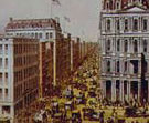
where tenements lined the avenues. Currier and Ives (American lithographic firm, 1857–1907) New York has consistently grown more quickly than anticipated; when City Hall was built in 1811, the city economized by facing only the south, east, and west walls with white marble, assuming that the common brownstone on the north wall "would be out of sight for years to come." However, by 1820 the city had already surrounded the building. In 1873, a depression slowed construction and even real estate values
declined, but within a few years prosperity returned, and all available
downtown space was in demand for offices, shops, and restaurants. Architects
started to build up –six and seven stories high –when elevators
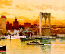
became the norm. Currier and Ives (American lithographic firm, 1857–1907) Considered the "eighth wonder of the world" at the time of its completion
in 1883, Brooklyn Bridge connected Manhattan to Brooklyn with an open span
of 1595 feet 5 inches, for a time the longest in the world. It cost its
designer, John Augustus Roebling, his life, and robbed his son, Washington
Roebling, of his health, but this monument has inspired generations of
writers and artists as a symbol of America. The critic Lewis Mumford wrote
that the bridge had become "a source of joy and inspiration to the artist,
perhaps the most completely satisfying structure of any kind that [has]
appeared in America." This view was published long before the bridge's
actual completion, in 1872, the year that Washington Roebling became a
victim of the bends while working on the western caisson. He continued
to supervise the project from his room on Columbia Heights in Brooklyn,
with the help of a telescope and his wife, Emily Warren Roebling, who communicated
his instructions to his crew. Currier and Ives (American lithographic firm, 1857–1907)
Charles Hart (American, active 1840–90s)
As the wholesale drygoods trade which once had filled Broad and Pearl
streets left for Park Place and later for the lofts of present-day Soho,
the pressing demand was for downtown office space to accommodate lawyers,
brokers, and corporations. Some of the last remnants of 18th-century New
York were sacrificed for new office buildings: the Old Middle Dutch Church,
which had been used as the Post Office, was purchased in 1881 by the Mutual
Life Insurance Company for $650,000, torn down, and replaced by an office
building. The 18th-century Kennedy mansion at No. 1 Broadway, by 1848 a
hotel, was bought in 1881 by Cyrus W. Field, who demolished it and put
up the Washington Building on that site. J. J. Fogerty (publisher, active about 1885–86)
Charles Graham (American, active about 1879–1905)
With the development of the steel skeleton and the passenger elevator,
buildings could grow upward, taking full advantage of increasingly valuable
downtown property. By 1875 the city already had several ten-story buildings,
including the Western Union building on Broadway and Dey and the Tribune building
on Nassau and Spruce. A cluster of tall buildings grew up around City Hall
in the 1880s, and at the end of that decade the Tower Building on 50 Broadway
won the distinction of introducing full steel skeleton, or skyscraper,
construction to the city. By the 1890s, the word "skyscraper" came into
common usage, as the first generation of steel skeleton buildings sprang
up downtown: Manhattan Life Building (1893–95) at 66 Broadway, American
Surety Building (1894–96) at 100 Broadway, Bowling Green Offices
(1895–98), Empire Building (1897–98), south of Trinity at Broadway
and Rector, and the Park Row Building (1896–99), which set the record
at 30 stories. Julius F. Gayler (American [architect], active late 1890s–1930s)
|