This website is part of The New York Public Library's Online Exhibition Archive. For current classes, programs, and exhibitions, please visit nypl.org.
  < Previous section | Next section >
< Abolitionists Intro | Image: 1 2 3 >


Slavery and Abolitionists

 
  Slave population of the southern states, 1861
Pointer to graphic links to enlargement Click here or on image to enlarge
  Map showing the distribution of the slave population of the southern states of the United States, compiled from the census of 1860
Washington: Census Office, 1861
NYPL, Humanities and Social Sciences Library, Map Division

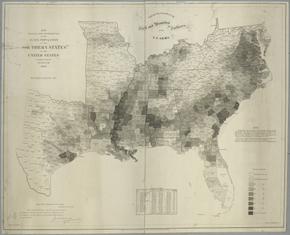
This map, which shows the distribution of the slave population of the southern states of the United States, was sold to benefit the sick and wounded soldiers of the North, the Grand Army of the Republic.

Reproductions and Permissions
 
Privacy Policy | Rules and Regulations | Using the Internet | Website Terms and Conditions | © The New York Public Library