![]()
Photographic Services & Permissions
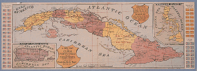
"A New Map of Cuba, Porto Rico and the Philippines revised to date."
Supplement to the Brooklyn Daily Eagle, May 8, 1898.
NYPL, Map Division
Colorful maps published as supplements to newspapers competed for the attention
of readers demanding geographical information and the latest war news. The public,
eagerly following the war events from afar, was provided with a means to plot
the progress of major battles during the short span of the war (notice the instructions
to readers of the Brooklyn Daily Eagle).
Introduction | Chronology | Part I: Antecedents, 1895-1898 | Part II: Public Appeals, 1898 | Part III: Popular Participation, 1898-1899 | Part IV: Public Memories | Part V: Historical Perspectives | Audiovisual Components | Exhibition Checklist | Acknowledgments | Suggested Reading /About the Library Shop | Related Exhibits/Spanish American War Websites of Interest | Exhibition home page | NYPL Exhibitions
EPO, 1998