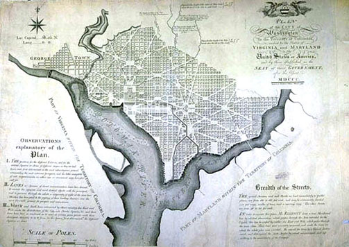
Photographic Services & Permissions Andrew Ellicott This first official plan of the City of Washington is based on an original manuscript survey by Ellicott, and was printed in Philadelphia, the temporary national capital until 1800, when the government moved to Washington. Each proposed block is numbered, streets are named, and soundings are given in the river. The following are noted on the map: "I. best sites selected for important buildings; II. best convenient & sightlines for avenues; III. Grid is N/S with divergent lines forming areas or squares." The map was surveyed professionally, as note the Scale of Poles 1" = 100 poles; a pole, rod or perch = 16 1/2' exactly. A herald angel and liberty cap angel are shown holding up a shield with three stars, two stripes, and an open book ("rights of Man"), all symbolic of this new capital for this newly free country. Again the 0° 0' longitude represents the mapmaker's statement of independence from London. |