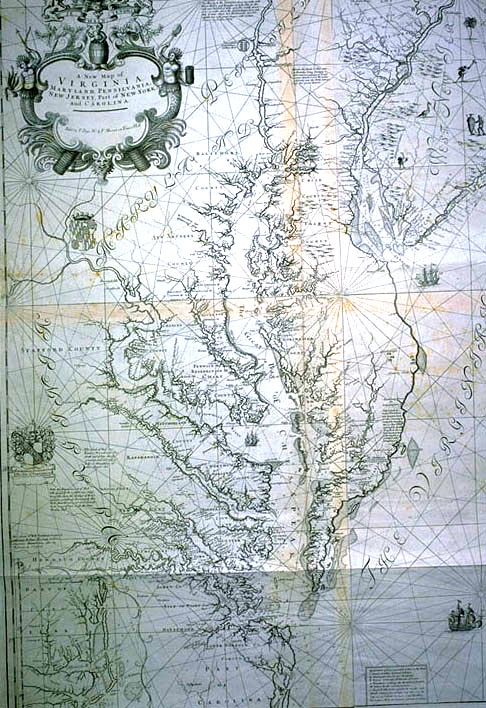
Photographic Services & Permissions John Thornton One of two known copies, this is the best map of the English colonies to date. It is probably the last great work of John Thornton, who died about 1705. It is a later state of an earlier map production, and was printed before his heir, Samuel Thornton, bothered to engrave his own name on the copper plate he had inherited. Map sales were apparently more important than map perfection! Oddly, this map was never reduced to atlas format, and never became a source for standard cartography. It was compiled from several excellent surveys. The New York and Carolina regions are based on Thornton's own 1689 English Pilot. Virginia is based on Augustine Hermann's 1673 map of the Chesapeake region. Densely packed coastal plantations are seen along the extensive Chesapeake waterways. Pennsylvania, with its bold portrayal of Philadelphia, is based on Thomas Holme's 1683 map of Philadelphia and John Seller's 1681 map of the south and east bounds of Pennsylvania. Southern New Jersey is based on John Worlidge's 1701 publication. Northeast Jersey is based on John Reid's 1683 Raritan map, possibly the earliest copperplate map produced in America. New Jersey is remarkably full of birdlife! The inset at the lower left corner carries the map down through the Carolina coast. Soundings are found offshore in the Delaware Bay, New York harbor, and off New Jersey. A 32-point compass rose, with named directions and rhumblines, decorates the Atlantic Ocean. The royal coat of arms of William III, who ruled from 1689 to 1702, decorates the upper left corner, enhanced by the motto of the Dutch royal family, "Je maintiendrai," or "I will maintain." William of Orange, the Dutch stadtholder, and his wife, Mary II, daughter of King James, were crowned King and Queen of England following the abdication of King James.There is a bit of irony, or perhaps whimsy, in this motto's being placed on this particular map, since the Dutch nation no longer had colonies in North America. The map is dedicated by Thornton to Mr. Micajah Perry, a wealthy London merchant, and former Lord Mayor of London. The firm of Perry, Lane and Co. were the greatest English traders in Virginia, even representing the business of the College of William and Mary in England. The map was possibly produced for the Board of Trade and Plantations. |
Return to Part VII Images | Return to Exhibit | Return to Checklist
Exhibition Home Page | Table of Contents
EPO, 1998