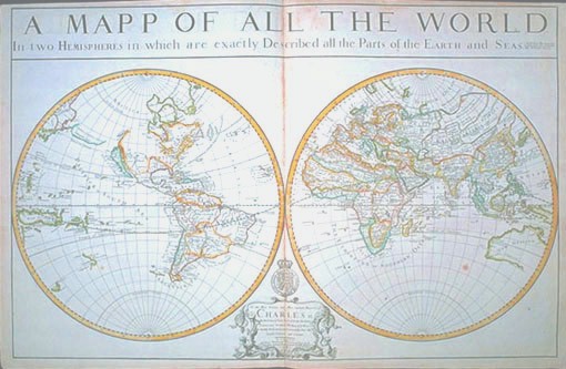
Photographic Services & Permissions William Berry The the late 17th-century English worldview is literally revealed on this double hemisphere map. California is an island, and the Pacific coastal region is patriotically named New Albion, after Sir Francis Drake's landfall there (Albion was an ancient name for England). The Western Atlantic is pompously labeled "Sea of Carolina, Virginia, N. York, N. England, N. Scotland." In the 16th and 17th centuries, the English were dependent on foreign mapmakers, whose works were copied freely. William Berry, derisively known in his own time as the "English Sanson," properly credits the French Royal Geographer, Nicolas Sanson, whose map he has copied closely; despite these French origins, this "Englished" map now seriously shrinks the apparent size of both French and Spanish incursions into North America. These are the earliest oversized maps of all parts of the world published in Britain, and this is just one map from the largest single collection of William Berry maps known, made up of 41 sheets. The emphatic and important dedication to Charles II honors the Restoration monarch who chartered the Royal Society, encouraging the study of the practical application of the sciences, navigation, and exploration. |