19th-century Reference Map
 Click here or on image to enlarge
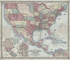
Map of the United States and Mexico
New York, 1859
NYPL, Humanities and Social Sciences Library, Map Division
This mid-19th-century map displays settlement patterns still seen today: densely populated Eastern states contrast with the more sparsely populated West. But the nation is on the brink of war, and everywhere the map seems in motion. Wagon roads follow paths of least resistance, the river valleys, as do the railroad lines, both existing and planned. Sailing ships dot the oceans, symbolizing trade and worldwide access to goods and markets. The stagecoach mail route to San Francisco from the railheads near St. Louis and Memphis is boldly marked, suggesting that this map was designed for use in places of business or local post offices. The Butterfield Stage carried the mail across the southwest until the railroads were completed and took over express services.
Reproductions and Permissions