HOW TO READ A MAP
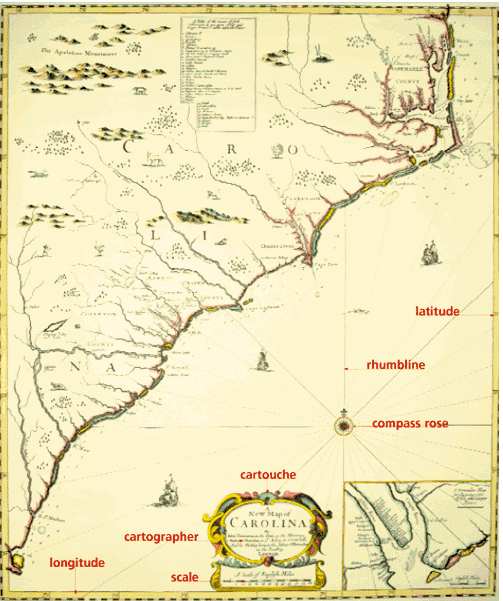
A map is a visual representation of a given location. Maps, both decorative and functional, have been made of the earth’s surface, the moon, a planet, the ocean floor, etc. A chart is used specifically for navigation. A portolan is an early, perhaps 15th- or 16th-century, hand-drawn nautical chart. Sometimes charts are contained in a pilot, a collection of written nautical directions. On old maps, information such as the title of the map and the names of the mapmaker and the author of the map, sometimes called a cartographer, usually appears in or near the cartouche, a highly decorative frame. Depictions of world ports, inhabitants in their ethnic dress, and land features were sometimes provided for additional reference. A coat of arms signified land ownership. However, direction and scale are the most important elements of a map. While on modern maps a north arrow indicates orientation, antique maps often have a compass rose or wind rose to show at least the four cardinal directions: north, east, south, and west. Wind roses sometimes have solid and dashed lines, called rhumblines, radiating out across the charts. These lines add a distinctive diagonal grid to many of the maps and charts in this exhibit. Distance on a map can be determined by the scale, which is shown by one or more ruled lines that mark off miles or other lengths of measure. On early maps, the scale indicator is sometimes decorated with a pair of dividers, an instrument used to measure distance on maps and charts. Most maps have a grid of latitude, which measures distance in increasing degrees north and south of the equator, and longitude, which measures distance in increasing degrees east and west of a prime meridian. Greenwich, England, is often designated the prime meridian on a map. The numbers of this grid, indicating the map’s location on the earth’s surface, appear at the border of the map. |
Exhibition Home Page | Table of Contents
EPO, 1998